

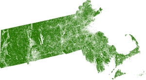
Massachusetts Tree Locations
The Massachusetts Tree Locations dataset is a high-resolution vector product that maps individual trees to support improved management of tree resources and 3D visualization. Trees are delivered as points, polygons and idealized circular crown polygons. It is derived from processing multiple terabytes of color infrared imagery from 2016 and LIDAR data flown between 2010 and 2015. LIDAR is a remote sensing technology that enables accurate measurement of elevation for different ground surface types based on the light pulses reflected from the earth.
What can you do with the Massachusetts Tree Locations data?
The Massachusetts Tree Locations dataset supports numerous applications for urban planning, 3D visualzation and ecosystem analysis.
Approach
A Digital Surface Model (DSM) was created from first returns of the LIDAR point cloud data and bare earth elevations were removed from the DSM to derive an above ground surface model. Buildings and tree canopy were differentiated in the above ground surface model using color infrared imagery through an expert rule based classification system. Tree heights were interpolated using the highest LIDAR return within each 1 meter pixel that was classified as tree canopy to generate the Canopy Height Model (CHM). The CHM was analyzed to discover potential tree peaks through an iterative spatial filtering process. The tree peaks were used as markers for creating tree crown polygons through watershed segmentation. The potential tree crown shapes were further analyzed using shape and spatial context to refine the final tree polygons.
Related Products
US Tree Map
Massachusetts Canopy Height Model (CHM)
Massachusetts Land Cover
Massachusetts Impervious Cover
Contact Us
Massachusetts Tree Locations Overview
| Technical Specifications | |
|---|---|
| Attributes | Tree ID Maximum Height Mean Height Crown Area |
| Height Units | Feet |
| Area | 7,655 sq. miles |
Latest Tweets @earthdefineLLC
Contact Us
8410 154th Avenue NE, Suite C-240
Redmond, WA 98052
Phone: 1.800.579.5916
Email: info@earthdefine.com
2021 © All Rights Reserved.