Looking for a sample covering a custom area?
Send us your AOI and we will send you a bespoke sample.
There's no better way to assess the fit between your project and our products than to download and evaluate some samples yourself. Open these files in your favorite GIS or RF planning tools (our data is compatible with all major software) and explore every feature and detail. Share them with your teammates, drop them into a presentation for your execs: the sky is the limit.

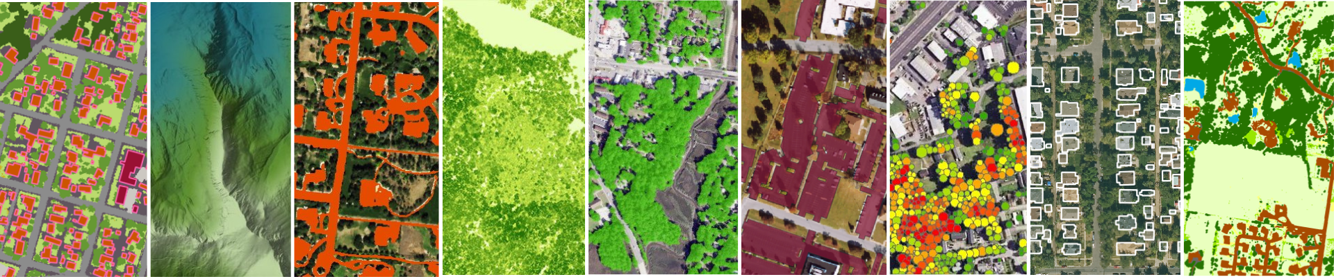
An EarthDefine building footprints sample contains vector building polygons for the area, each with a rooftop outline, height and estimated-stories attributes, and a street address. Use it for rooftop geocoding, 3D city models, 5G and RF planning, insurance risk modelling, and population mapping. It is used by telecom, insurance, government, utilities, and urban-planning teams.
Building footprints for Columbia, SC: rooftop polygons with heights, estimated stories, and street addresses.
view on mapBuilding footprints for Redmond, WA: rooftop polygons with heights, estimated stories, and street addresses.
view on mapHuntsville, Alabama · Perryville, Arizona · Phoenix, Arizona · Goleta, California · Denver, Colorado · New Haven, Connecticut · Washington, DC · Milford, Delaware · Orlando, Florida · Darien, Georgia · Iowa Falls, Iowa · Montpelier, Idaho · Oregon, Illinois · Fishers, Indiana · Clyde, Kansas · Lexington, Kentucky · Baton Rouge, Louisiana · Deerfield, Massachusetts · Pasadena, Maryland · Ashland, Maine · Drummond, Michigan · Minneapolis, Minnesota · Rolla, Missouri · Waveland, Mississippi · Ronan, Montana · Leland, North Carolina · Minot, North Dakota · West Point, Nebraska · Lincoln, New Hampshire · Parlin, New Jersey · Las Cruces, New Mexico · Reno, Nevada · Yonkers, New York · Columbus, Ohio · Edmond, Oklahoma · Burns, Oregon · Milton, Pennsylvania · Narragansett, Rhode Island · Columbia, South Carolina · Rapid City, South Dakota · Nashville, Tennessee · Dallas, Texas · Cedar City, Utah · Roanoke, Virginia · Swanton, Vermont · Redmond, Washington · Appleton, Wisconsin · Charleston, West Virginia · Rock Springs, Wyoming
Need a different area? Request a custom sample for your AOI ›

An Impervious Map sample contains a high-resolution (60cm) raster of impervious surfaces, buildings, roads, sidewalks, parking lots and more, mapped as a single class. Use it for stormwater runoff and water-quality modelling, urban heat-island analysis, TMDL studies, and dasymetric population mapping. It is used by stormwater and environmental engineers, municipalities, and watershed planners.
Impervious surfaces for Philadelphia, PY: a 60cm raster of buildings, roads, and paved areas mapped as one class.
Impervious surfaces for Wright, UT: a 60cm raster of buildings, roads, and paved areas mapped as one class.
Catalina Foothills, Arizona · Fresno, California · Aurora, Colorado · Orlando, Florida · Winterset, Iowa · Bozeman, Montana · Fargo, North Dakota · Wildwood, New Jersey · Albuquerque, New Mexico · Massapequa, New York · Philadelphia, Pennsylvania · Knoxville, Tennessee · Houston, Texas · Wright, Utah · Redmond, Washington
Need a different area? Request a custom sample for your AOI ›

A Parking Lots sample contains vector polygons of paved parking areas across the AOI. Use it for EV-charging and site-selection studies, impervious-surface and stormwater analysis, and retail and real-estate planning. It is used by EV-infrastructure planners, retailers, civil engineers, and municipalities.
Parking-lot polygons for Greenville, NC, ready for site-selection and stormwater analysis.
Parking-lot polygons for El Paso, TX, ready for site-selection and stormwater analysis.
Simi Valley, California · Overland Park, Kansas · Greenville, North Carolina · El Paso, Texas
Need a different area? Request a custom sample for your AOI ›

A Tree Map sample contains a high-resolution (60cm) raster of tree-canopy presence and absence for the area. Use it for urban tree-canopy (UTC) assessments, wildfire defensible-space analysis, carbon storage and sequestration, and utility vegetation risk. It is used by city foresters, utilities, environmental consultants, and researchers.
Tree-canopy raster for Birmingham, AL at 60cm: presence and absence of woody vegetation.
Tree-canopy raster for Little Rock, AR at 60cm: presence and absence of woody vegetation.
Birmingham, Alabama · Little Rock, Arkansas · Grand Canyon National Park, Arizona · Loyola, California · Silverton, Colorado · Farmington, Connecticut · Washington, DC · Dover, Delaware · Cape Coral, Florida · Savannah, Georgia · Council Bluffs, Iowa · Stanley, Idaho · Chicago, Illinois · Fort Wayne, Indiana · Manhattan, Kansas · Pikeville, Kentucky · New Orleans, Louisiana · Boston, Massachusetts · Baltimore, Maryland · Portland, Maine · Lansing, Michigan · Mississippi Headwaters, Minnesota · St. Louis, Missouri · Gulfport, Mississippi · Lewistown, Montana · Asheville, North Carolina · Bismarck, North Dakota · Lincoln, Nebraska · Nashua, New Hampshire · Newark, New Jersey · Taos Ski Valley, New Mexico · Reno, Nevada · Ithaca, New York · Columbus, Ohio · Coweta, Oklahoma · Bend, Oregon · Conyngham, Pennsylvania · Cumberland, Rhode Island · Hilton Head Island, South Carolina · Mount Rushmore National Memorial, South Dakota · Knoxville, Tennessee · Austin, Texas · Salt Lake City, Utah · Chesapeake, Virginia · Burlington, Vermont · Redmond, Washington · Madison, Wisconsin · Morganville, West Virginia · Yellowstone National Park, Wyoming
Need a different area? Request a custom sample for your AOI ›

A Tree Locations sample contains individual tree features, points, crown polygons, and heights, for the area. Use it for tree inventory and asset management, utility vegetation management, and right-of-way planning. It is used by city foresters, utilities, and arborists.
Individual tree points, crown polygons, and heights for Palo Alto, CA: ready for inventory and asset management.
Individual tree points, crown polygons, and heights for Boulder, CO: ready for inventory and asset management.
Palo Alto, California · Boulder, Colorado · Boston, Massachusetts
Need a different area? Request a custom sample for your AOI ›

A Canopy Height Model sample contains a 60cm raster where each pixel records tree-overstory height above the ground, derived from LiDAR. Use it for forestry metrics, fuel-load and wildfire modelling, line-of-sight and RF planning, and solar-shade analysis. It is used by foresters, utilities, wireless planners, and wildfire agencies.
A canopy-height sample for Palo Alto, CA: a 60cm raster of tree-overstory height above ground, derived from LiDAR.
A canopy-height sample for Boulder, CO: a 60cm raster of tree-overstory height above ground, derived from LiDAR.
Palo Alto, California · Boulder, Colorado · Belmont, Massachusetts
Need a different area? Request a custom sample for your AOI ›

A Land Cover sample contains a high-resolution multi-class land-cover raster for the area, covering vegetation, water, built surfaces, bare ground, and more. Use it for land-cover change detection, hydrology and habitat modelling, and planning. It is used by government agencies, environmental consultants, and researchers.
Multi-class land cover for Cape Coral, FL at high resolution.
Multi-class land cover for Eugene, OR at high resolution.
Boulder, Colorado · Grand Junction, Colorado · Cape Coral, Florida · Miami Beach, Florida · Eugene, Oregon · Vancouver, Washington
Need a different area? Request a custom sample for your AOI ›

A Clutter3D sample contains a 20-class RF clutter dataset at 1m resolution with per-pixel LiDAR heights, plus DSM/AGL, DEM/AMSL, building vectors, and source imagery. Use it for RF propagation modelling and 5G network planning in tools like Atoll, Planet, and EDX. It is used by telecom operators, RF engineers, and network-planning vendors.
A 20-class RF clutter sample with per-pixel LiDAR heights, plus DSM, DEM, and building vectors.
A 20-class RF clutter sample with per-pixel LiDAR heights, plus DSM, DEM, and building vectors.
Need a different area? Request a custom sample for your AOI ›

A DEM/DSM sample contains bare-earth (DEM) and surface (DSM) elevation rasters for the area. Use it for terrain analysis, viewshed and line-of-sight studies, flood and drainage modelling, and RF planning. It is used by civil engineers, telecom planners, and GIS analysts. Samples for other areas are available on request.
A DEM/DSM sample with bare-earth and surface elevation rasters for terrain, viewshed, drainage, and RF work.
A DEM/DSM sample for Jacksboro, TX, with bare-earth and surface elevation rasters for terrain, viewshed, drainage, and RF work.
Need a different area? Request a custom sample for your AOI ›
Send us your area of interest and our data experts will generate a bespoke sample for the products you need.