EarthDefine Driveways
Nearing release. Driveway polygons with length, average, minimum, and maximum width, plus linked access points at the roadway and building.
EarthDefine Driveways will map the paved surface between the roadway and the building, with driveway length and average, minimum, and maximum width delivered as attributes. Roadway and structure access points will identify where the driveway connects to the roadway pavement and the building footprint.
Driveway polygons support impervious-area accounting, stormwater fee assessment, and property characterization. Length helps teams identify long approaches, while width measurements help screen properties for narrow access. The two access points show where to enter the property and which building face the driveway serves.
The polygons and access points come from the same imagery pipeline that produces EarthDefine Building Footprints. All three outputs are linked by building ID, so teams can examine the driveway surface, its measurements, and its connection to the building together.
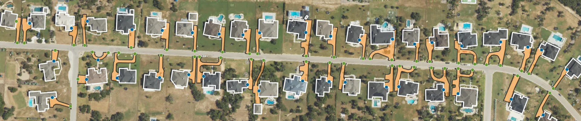
A straight-line distance can miss the bends in a driveway. The mapped driveway geometry shows how the approach connects the roadway to the building.
Three linked geometry outputs, with driveway length and width measurements delivered as polygon attributes.
Driveway Polygons. The mapped paved surface of the driveway, delivered as a vector polygon linked to its building and both access points. Use its area and geometry for stormwater assessment, impervious surface analysis, and property characterization.
Driveway Length. Get driveway length as a delivered attribute for property analysis and access planning. Average, minimum, and maximum width are included alongside length, helping teams identify long approaches and narrow sections for further review.
Roadway and Structure Access Points. One point marks where the driveway meets the roadway pavement; the other marks where it meets the building footprint. Both are linked by building ID, showing where to enter the property and which building face the driveway serves.
Driveway polygons and access points linked to building footprints show how each mapped driveway connects the roadway to the building it serves.
The mapped driveway geometry shows a winding approach between the roadway access point and the building footprint.
| Driveway Polygons | Roadway Access Points | Structure Access Points | |
|---|---|---|---|
| Feature type | Polygon | Point | Point |
| Located at | The mapped paved driveway surface | Edge of the roadway pavement | Edge of the building footprint |
| Answers | Driveway area, length, average width, minimum width, and maximum width | Where to enter the property | Which building face the driveway serves |
| Typical buyers | Stormwater utilities, insurers, assessors, planners | Navigation, delivery, ride-share, emergency services, 911 | Emergency services, 911, field service, insurers, utilities |
| Links to | Building footprint and both access points, by building ID | Building footprint and driveway polygon, by building ID | Building footprint and driveway polygon, by building ID |
The driveway polygon and both access points are linked by building ID. Length and width measurements are delivered as attributes of the driveway polygon.
Derived from mapped driveway surfaces. Our models use high-resolution aerial imagery to identify the driveway surface, then place one access point where it connects to the roadway pavement and another where it meets the building footprint. Neither point is generated by dividing a roadway segment across an address range.
Independent of delivery history. The extraction process does not require GPS traces or previous vehicle visits. It can be applied to locations with little delivery activity, provided the source imagery shows a driveway that can be extracted.
Works with your roadway network. Both access points are delivered as coordinates linked by building ID. Your team can use them alongside its existing roadway network to identify property entrances and building-side connections.
Our internal benchmarking compares EarthDefine roadway access points with access points from commercial geocoders. Across audited samples, the median correction was:
The audited examples include estimated access points placed inside a parcel or along a boundary without a driveway entrance, and points placed closer to a neighboring driveway than to the correct one. These errors can direct a driver or responder to the wrong property.
Figures reflect internal audits of sampled areas and are not a nationwide accuracy statement.
A long, curved driveway, with the structure access point connecting to the main building.
A corner house at an intersection, with a driveway connecting to both roads.
A corner house at an intersection, with a driveway connecting to only one of the two roads.
Multiple driveways branching off a single road, numbered 1 to 5 in clockwise order.
Municipal stormwater utilities use driveway polygons to quantify paved surface area per parcel for impervious-area accounting and fee assessment.
Property insurance and underwriting teams use driveway length, width measurements, and geometry to characterize property access without manually measuring each driveway. These attributes help identify long approaches and narrow sections for further review.
Navigation, ride-hail, and delivery teams use the roadway access point to identify the driveway entrance. The structure access point shows which building face the driveway serves after a vehicle enters the property.
Emergency dispatch and 911 teams can use the mapped driveway and both access points to review the approach from the roadway to the building. Driveway length adds context for properties with long approaches.
Field service and utilities use driveway length, average width, and minimum and maximum width to screen access before sending crews and equipment. The mapped geometry and structure access point help teams review the approach and its connection to the building.
Extraction completeness varies by location. Dense tree canopy, unpaved and shared driveways, and older imagery can limit what can be mapped. Both access points are derived from the driveway polygon and are available only where that polygon can be extracted.
We will produce Driveways to order using the latest available imagery for your area. Contact us to discuss planned coverage and source imagery.
Need more frequent updates? Ask about satellite updates for your area.
| Driveway Polygons | Roadway Access Points | Structure Access Points | |
|---|---|---|---|
| Geometry | Polygons | Points | Points |
| Formats | File Geodatabase, Shapefile, GeoJSON, CSV | File Geodatabase, Shapefile, GeoJSON, CSV | File Geodatabase, Shapefile, GeoJSON, CSV |
| Coordinate system | EPSG:4326 (WGS 84) | EPSG:4326 (WGS 84) | EPSG:4326 (WGS 84) |
| Source | 30-60cm aerial imagery | Derived from driveway polygons, roadway edge, and building footprints | Derived from driveway polygons and building footprints |
| Attributes | Area (sq ft), length, average width, minimum width, maximum width, linked building ID | Latitude, longitude, linked building ID | Latitude, longitude, linked building ID |
| NENA Placement Method | N/A | PropertyAccess | Structure |
| Coverage | Contiguous U.S. + HI, PR, VI | Contiguous U.S. + HI, PR, VI | Contiguous U.S. + HI, PR, VI |
| Production | Produced to order using the latest available imagery | Produced to order using the latest available imagery | Produced to order using the latest available imagery |
Driveway polygons will include area, length, average width, minimum width, and maximum width. These attributes will be delivered with the geometry and linked building ID.
The straight-line distance between the access points does not describe bends in a driveway. Use the delivered driveway length attribute for length-based analysis, and the polygon geometry to examine the shape of the approach.
Driveways maps paved access surfaces between the roadway and a building as individual polygons, with length and width measurements and linked access points. Parking Lots covers off-street parking areas. The Impervious Map is a raster of impervious surfaces.
The roadway access point marks where the driveway meets the edge of the roadway pavement. The structure access point marks where it meets the building footprint. Both are linked to the driveway and building by building ID.
The roadway access point identifies the entrance to the property. The structure access point identifies the building-side connection. Together with the driveway polygon, they show how the approach connects the roadway to the building.
Contact us to discuss planned coverage in your area. Extraction completeness will vary with imagery age, tree canopy, and driveway surface type. Both access points are available only where the driveway polygon can be extracted.
Yes. We can update Driveways for your area every six months or annually using commercial satellite imagery. We can also use satellite imagery you’ve purchased after checking that it works with our models. Satellite updates cost more than our standard data, and using your own imagery may add to the cost depending on the validation required. Pricing is per project, with a $1,000 minimum order. Contact us to discuss timing.
EarthDefine derives its access points from driveway surfaces mapped in aerial imagery. The extraction process does not require delivery history or GPS traces. Our internal benchmark results above describe corrections relative to commercial geocoder access points in sampled areas.
Both access points are delivered as coordinates linked by building ID, with no roadway network geometry included. Your team can use them alongside its existing roadway network.
Yes. The roadway access point identifies the driveway entrance, and the structure access point identifies where the driveway meets the building footprint. The proposed NENA Placement Method mappings are PropertyAccess and Structure, respectively. Contact us to confirm the delivered fields and how these locations fit your agency’s address-point schema and placement requirements.
Samples are for evaluation only and cannot be redistributed, resold, or used in production without a license. Contact us for coverage, licensing, and pricing.
Pricing is per project, with a $1,000 minimum order. We produce the data to order, and delivery timing depends on the size of your area. Send us your area of interest for a quote and delivery estimate.
EarthDefine Driveways is nearing release. Tell us where you need data, and ask our team about evaluation samples, planned coverage, and licensing.