Free or paid building footprint data: how to choose for your project
Oct 6, 2026
Public building footprint datasets are enough for many projects. Here is how to tell when yours needs more, and how to test the options before you commit.
Start with the public datasets and see whether they answer your question. Microsoft US Building Footprints, Overture Maps Buildings and FEMA USA Structures are all free to download, and for many projects one of them will do. A paid dataset is worth evaluating when your project needs something they do not provide, or when filling the gaps yourself would cost more than a license.
A note on perspective: EarthDefine sells a commercial building footprint dataset, and this article draws on our buyer's guide, which compares our data with those three public options. Test every claim, ours included, on places you know.
When a public dataset may be enough
Public data can be the right choice for exploratory maps, prototypes, and any analysis where an approximate outline does the job. If you are counting buildings in an area, checking whether a property has a structure on it, or placing a point on each rooftop, a simplified outline, or even a single point per building, may be all you need.
The public datasets also differ from each other, so check each one against your requirements. As checked for our guide in 2026, FEMA USA Structures is published as public domain, although some of its data may be subject to copyright. Microsoft's US release and Overture's buildings theme are published under the Open Database License (ODbL), which requires attribution and can require you to share a combined database you make public. Overture carries heights for many of its structures and states a monthly release cadence. FEMA's heights are measured from LiDAR but limited to 133 cities, and Microsoft's US release has no height attribute.
When to look more closely
Treat each of these as its own question:
- Outline detail. Does the shape need to follow the roof? Rooftop solar layouts, roof estimates and flood or wildfire checks can change when an outline is simplified.
- Completeness. Are all the buildings there? Totals and gaps vary by dataset and by state, so check the places you work.
- Source dates. How recent is the imagery or LiDAR behind each footprint, and does the dataset record that date per building?
- Parcels and addresses. Do you need one record per property lot, or an address attached to each building? The public datasets generally give one footprint per structure.
- Heights. Are heights measured from LiDAR or estimated, and how many buildings have them?
- Attribute accuracy. For each field you plan to use, what does the provider publish about how it was checked?
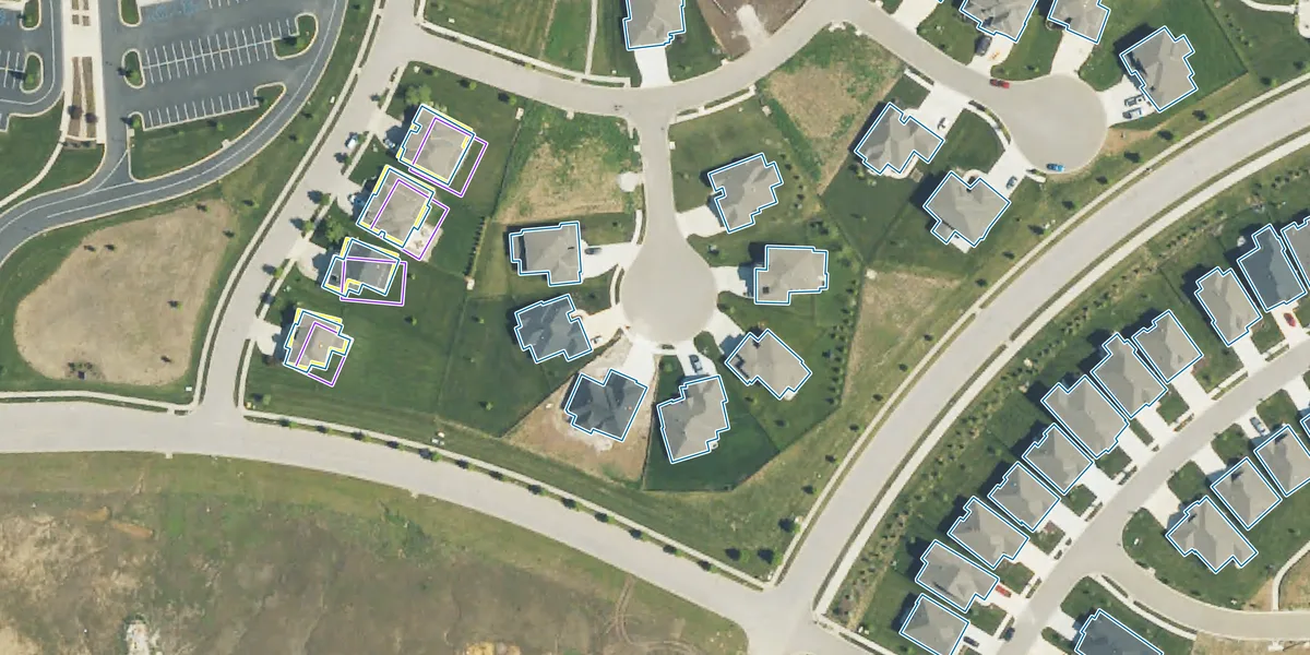
FEMA USA Structures: one merged polygon
EarthDefine Building Footprints 3D: split at the parcel lines
One townhome row, two datasets. The public dataset represents the attached row as a single polygon; EarthDefine delivers one building record per parcel. From Figure 1b of the buyer's guide.
Count the work as well as the price
Free data has no license fee, but preparing it can still take real effort. When a public dataset falls short, your team takes on the gap: finding missing structures, correcting outlines, splitting buildings at parcel boundaries, matching addresses, and processing LiDAR for heights. That work needs time and expertise, and it has to be repeated whenever the source data changes.
A paid dataset moves some of that work to the provider. The useful comparison is the license price against the preparation, review and maintenance you would otherwise carry over the life of the project. License terms belong in the same calculation, since share-alike obligations can affect how you combine and distribute data in a commercial product. That part is a question for your counsel.
Test on locations you know
Before choosing, pick a few representative locations: a dense downtown block, a suburb with attached housing, a rural area, and somewhere that has changed recently. Load each candidate dataset over recent imagery and check the outlines, missing buildings, source dates, and any attributes you plan to use.
For that check, EarthDefine offers free Building Footprints 3D sample data. The buyer's guide sets out our full comparison, with the sources behind each figure and the dates they were checked.
Related products
Building Footprints 3D
202M+ buildings mapped, with heights and elevations. Available off-the-shelf.
Learn more