What counts as a building? Understanding building footprint data
Oct 19, 2026
A building footprint is the outline of a building seen from above. Which structures get one, and how they are counted, decides what a dataset's numbers mean.
A building footprint is the outline of a building as seen from directly above, stored as a shape (a polygon) on a map. Footprint datasets let you count buildings, measure their area, and connect them to addresses and property lines. Before relying on any of those numbers, it helps to know what the dataset treats as a building, because every provider has to draw that line somewhere.
This article walks through the rules EarthDefine uses for its Building Footprints 3D dataset. The full reference is the Building Footprints 3D technical specification.
The basic rule: a permanent structure with a roof
In our dataset, a building is a permanent structure with a roof, and that one definition settles most edge cases. Houses, offices, warehouses and parking garages are the obvious ones. Less obvious structures are included too: gas-station canopies, covered walkways between buildings of the same hospital or campus, greenhouses, water towers, silos, and roofed structures at the end of docks. Detached sheds and outbuildings are captured as separate buildings.
Things that move, or that have no permanent roof, are left out. That covers RVs, campers, boats, vehicles and shipping containers, as well as tents, uncovered docks, pools, patios, standalone solar arrays, wind turbines and transmission towers.
Included: solar panels that also roof a parking lot
Excluded: a standalone ground-mounted solar array
Same panels, different answer. Solar panels that also serve as a roof over parking count as a building; a ground-mounted array does not. From Figure 5.5 of the technical specification.
What the outline traces
Our footprints follow the roof edge, including any roof overhang, rather than the exterior walls or the foundation. A footprint's area can therefore be larger than the area enclosed by the walls.
A few more rules shape the polygon. Open courtyards inside a building are cut out of it. Raised decks and balconies are included, while ground-level patios are not. An attached garage is part of the house's footprint, and a detached garage is a building of its own.
Structures, buildings and addresses are different counts
The specification uses three units, and keeping them apart makes footprint numbers much easier to read.
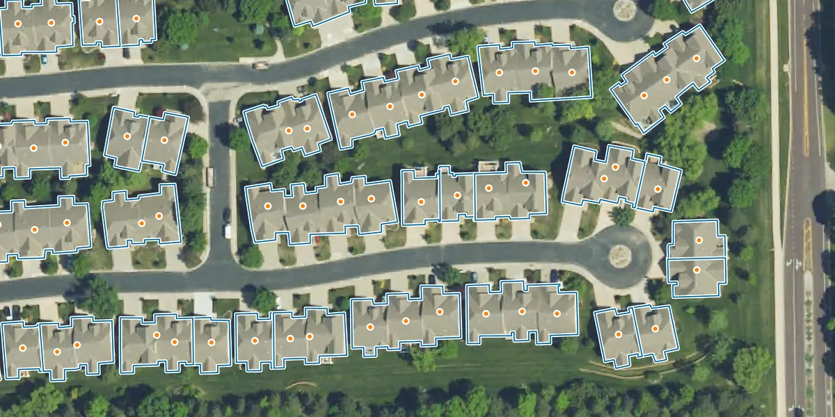
- Structure: one connected physical building mass. A row of attached townhomes is one structure.
- Building: a structure split at parcel boundaries (a parcel is a legal property lot). A townhome row of eight homes on eight parcels is one structure and eight buildings.
- Address: an address point inside a building. A duplex can have one address per unit, while a house and its shed on the same lot can share one address.
Aerial imagery of an eight-unit townhome row
Delivered footprints: one structure, eight buildings
One structure, eight buildings. The attached row is one connected structure, split into eight building records at the parcel lines. From Figure 5.1 of the technical specification.
Why the definitions change the numbers
In EarthDefine's figures as of October 14, 2026, Building Footprints 3D holds 203,474,752 buildings and 194,555,029 structures. The difference comes from the parcel splits.
The large public datasets generally provide one footprint per structure rather than parcel-split records, so set our building count against their totals and the gap looks bigger than it is. Compare structures with structures.
Measurements depend on the definitions as well. A total of building area per parcel depends on whether attached homes were split at the lot lines. A count of buildings per address depends on how sheds and garages are handled, and an area depends on whether the outline follows the roof or the walls. When two datasets disagree, check how each one defines a building before deciding which is wrong.
See the rules on real data
The technical specification lists every capture rule with illustrated examples, along with the full list of fields. To see how the rules play out somewhere you know, download free Building Footprints 3D sample data for one of the available cities.
Related products
Building Footprints 3D
202M+ buildings mapped, with heights and elevations. Available off-the-shelf.
Learn more